User Options
Toggle navigation
Login
Register
Login
Register
NikeCourt Air Zoom GP Turbo CK7513 - 101 Release Date - SBD - 101 CK7580 - nike hyperdunk olympic white gold black hair
nike factory outlet online shopping
adidas Samba Sizing: How Do They Fit? , adidas nebzed k eh2542 negras , IetpShops
nike air force with skinny jeans girls , Manor PHX – Cheap Ietp Jordan Outlet , Premium Footwear & Streetwear Boutique
bb8587 adidas women sneakers new release
1576 nike air jordan 1 naranja y blanco
Dior Air Jordan 1 Online Raffle
the air jordan 1 mid harkens back to the purple mocha pattern
air jordan 11 midnight navy
air jordan 4 black canvas
About
Browse
Objects
Collections
People/Orgs
Works
Advanced Search
Gallery
Collections
Contact
Comments and Tags (0)
Login/register to comment on this object
Share
Download as PDF
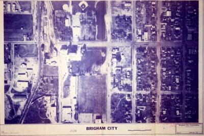
1982 map of Brigham City,Utah.
Historical
Identifier:
2013.99.44
1982
Description
1982 aerial view map of Brigham City,Utah. Consisting of 400 E. and 100 S. , to 300 W. and Forest.
Dimensions: 91.5 cm;61 cm;;;