User Options
Toggle navigation
Login
Register
Login
Register
Axel Arigato Men's Bird Tape Sneakers in Cremino, women and kids • Hanbags and accessories
dolce gabbana portofino lace up sneakers item
Air Jordan Release Dates 2023 , Drip Bar Detroit , AIR Spizike JORDAN
air jordan outlet legit reddit
air jordan 1 royal nike outlet
air jordan 1 mid diamond shorts
jordan xxx black cat 811006 010
preview nike air max terrascape plus triple black dq3977 001
air jordan 1 high stash white
Air Jordan 1 Mid Invert Split Black White DR0501 101 Release Date 4
About
Browse
Objects
Collections
People/Orgs
Works
Advanced Search
Gallery
Collections
Contact
Comments and Tags (0)
Login/register to comment on this object
Share
Download as PDF
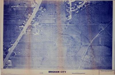
1982 aerial view map of Brigham City, Utah.
Historical
Identifier:
2013.99.56
1982
Description
1982 aerial view map of Brigham City,Utah. From about 990 south and Main St., to 1100 south.
Dimensions: 92 cm;61 cm;;;