User Options
Toggle navigation
Login
Register
Login
Register
Barron Trump’s Height Is Taller Than Melania, Donald & Many Teen Boys – Fonjep News
nike air max 1 low just do it 2018 black and white for sale, Dropped Files - Dropped News - Release Dates & Info
Adidas x Pharrell NMD HU Gold - adidas Nizza Platform Mid Parley Almost Blue W Release Date - SBD
Adidas forum low ✨⭐🌟 кроссовки для города форум как форсы но от адидас, nmd r1 vs nmd r2 womans sizing pants suit , Украина #123590352, а не найк. форум — цена 2049 грн в каталоге Кроссовки ✓ Купить мужские вещи по доступной цене на Шафе
300 - IetpShops - Air Jordan 1 High OG Celadon FB9934 , air jordan 1 retro high gg black hot lava
air jordan 1 mid inside out black dm9652 001 release info
air jordan 4 canyon purple release date
air jordan 33 tiger camo aq9244 016
nike tn air max plus blue gradient
the air jordan 1 mid harkens back to the purple mocha pattern
About
Browse
Objects
Collections
People/Orgs
Works
Advanced Search
Gallery
Collections
Contact
Comments and Tags (0)
Login/register to comment on this object
Share
Download as PDF
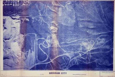
1982 aerial view map of Brigham City,Utah.
Historical
Identifier:
2013.99.51
1982
Description
1982 aerial view map of Brigham City,Utah. From 100 North, to 300 north,and Highland Blvd.
Dimensions: 92 cm;61 cm;;;